![](/images/other/stat-length.png)
![Randonnée Marche Le Pin-au-Haras - Versailles du cheval - Le Pin au Haras - Photo](https://media.geolcdn.com/t/1900/400/ext.pjpeg?maxdim=2&url=https%3A%2F%2Fservices.sitytrail.com%2FGeolivesWS%2FDownloadMedia.ashx%3FTrailID%3D111666%26Media%3D7904_2.jpg)
Versailles du cheval - Le Pin au Haras
tracegps
Utilisateur
![Longueur](/images/other/stat-length.png)
Longueur
6,9 km
![Altitude max](https://static1.geolcdn.com/siteimages/upload/files/1508320355ic_sort_altitude_max_24dp.png)
Altitude max
251 m
![Dénivelé positif](https://static1.geolcdn.com/siteimages/upload/files/1508320355ic_sort_den_pos_24dp.png)
Dénivelé positif
114 m
![Km-Effort](/images/other/stat-length.png)
Km-Effort
8,4 km
![Altitude min](https://static1.geolcdn.com/siteimages/upload/files/1508320355ic_sort_altitude_min_24dp.png)
Altitude min
175 m
![Dénivelé négatif](https://static1.geolcdn.com/siteimages/upload/files/1508320355ic_sort_den_neg_24dp.png)
Dénivelé négatif
114 m
![Boucle](https://static1.geolcdn.com/siteimages/upload/files/16400158638029165_repeat_loop_refresh_sync_direction_icon.png)
Boucle
Oui
Date de création :
2014-12-10 00:00:00.0
Dernière modification :
2014-12-10 00:00:00.0
![Marche](https://static1.geolcdn.com/sitytour/trail-icons/101.png)
2h19
Difficulté : Moyen
![Scannez ce code QR pour ouvrir la randonnée dans l'application SityTrail](https://capi.geolives.com/qq0zvz2zws4bq2lad0pu/sitytour/trails/111666/qr.png?size=200)
Application GPS de randonnée GRATUITE
À propos
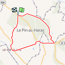
Randonnée Marche de 6,9 km à découvrir à Normandie, Orne, Le Pin-au-Haras. Cette randonnée est proposée par tracegps.
Description
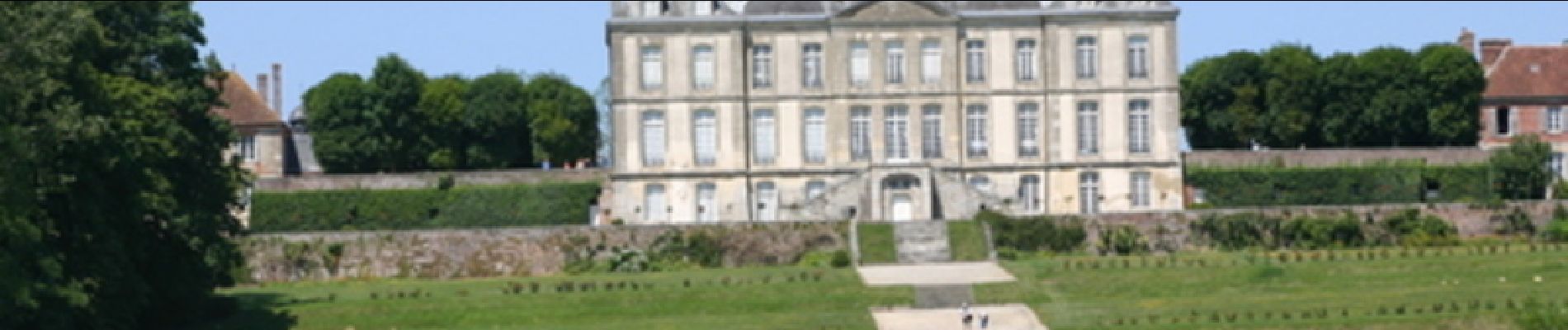
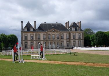
Versailles du cheval - Le Pin au Haras. Au pays du cheval et des haras, découvrez le site du prestigieux Haras National du Pin, véritable "Versailles du Cheval". Retrouvez les Coup de Cœur Randonnée dans l’Orne en Normandie.
Localisation
Pays :
France
Région :
Normandie
Département/Province :
Orne
Commune :
Le Pin-au-Haras
Localité :
Unknown
Départ:(Dec)
Départ:(UTM)
289309 ; 5403767 (31U) N.
Commentaires
Randonnées à proximité
![Randonnée V.T.T. Gouffern en Auge - Randonnée VTT - Le Bourg Saint Léonard - Photo](https://media.geolcdn.com/t/375/260/ext.jpg?maxdim=2&url=https%3A%2F%2Fservices.sitytrail.com%2FGeolivesWS%2FDownloadMedia.ashx%3FTrailID%3D214869%26Media%3D15415_1.jpg)
![V.T.T. V.T.T.](https://static1.geolcdn.com/sitytour/trail-icons/202.png)
Randonnée VTT - Le Bourg Saint Léonard
V.T.T.
Difficile
(1)
Gouffern en Auge,
Normandie,
Orne,
France
![](/images/other/stat-length.png)
43 km | 53 km-effort
2h 30min
![](https://static1.geolcdn.com/siteimages/upload/files/16400158638029165_repeat_loop_refresh_sync_direction_icon.png)
Oui
![Randonnée Cheval Gouffern en Auge - Boucle du Bourg-St-Leonard - Photo](https://media.geolcdn.com/t/375/260/ext.jpg?maxdim=2&url=https%3A%2F%2Fservices.sitytrail.com%2FGeolivesWS%2FDownloadMedia.ashx%3FTrailID%3D112044%26Media%3D9572_2.jpg)
![Cheval Cheval](https://static1.geolcdn.com/sitytour/trail-icons/300.png)
Boucle du Bourg-St-Leonard
Cheval
Difficile
Gouffern en Auge,
Normandie,
Orne,
France
![](/images/other/stat-length.png)
20 km | 23 km-effort
5h 0min
![](https://static1.geolcdn.com/siteimages/upload/files/16400158638029165_repeat_loop_refresh_sync_direction_icon.png)
Oui
![Randonnée Marche Le Pin-au-Haras - Le Haras du Pin - Photo](https://media.geolcdn.com/t/375/260/ext.jpg?maxdim=2&url=https%3A%2F%2Fstatic1.geolcdn.com%2Fsiteimages%2Fupload%2Ffiles%2F1553511878bg_sport_marche.png)
![Marche Marche](https://static1.geolcdn.com/sitytour/trail-icons/101.png)
Le Haras du Pin
Marche
Moyen
Le Pin-au-Haras,
Normandie,
Orne,
France
![](/images/other/stat-length.png)
29 km | 34 km-effort
6h 28min
![](https://static1.geolcdn.com/siteimages/upload/files/16400158638029165_repeat_loop_refresh_sync_direction_icon.png)
Oui
![Randonnée Marche Le Pin-au-Haras - La Boucle du Pin - Photo](https://media.geolcdn.com/t/375/260/ext.jpg?maxdim=2&url=https%3A%2F%2Fstatic1.geolcdn.com%2Fsiteimages%2Fupload%2Ffiles%2F1553511878bg_sport_marche.png)
![Marche Marche](https://static1.geolcdn.com/sitytour/trail-icons/101.png)
La Boucle du Pin
Marche
Facile
Le Pin-au-Haras,
Normandie,
Orne,
France
![](/images/other/stat-length.png)
6,8 km | 8,4 km-effort
2h 0min
![](https://static1.geolcdn.com/siteimages/upload/files/16400158638029165_repeat_loop_refresh_sync_direction_icon.png)
Oui
![Randonnée Marche Gouffern en Auge - Bourg St Leonard (boucle) - Photo](https://media.geolcdn.com/t/375/260/ext.jpg?maxdim=2&url=https%3A%2F%2Fstatic1.geolcdn.com%2Fsiteimages%2Fupload%2Ffiles%2F1553511878bg_sport_marche.png)
![Marche Marche](https://static1.geolcdn.com/sitytour/trail-icons/101.png)
Bourg St Leonard (boucle)
Marche
Moyen
Gouffern en Auge,
Normandie,
Orne,
France
![](/images/other/stat-length.png)
20 km | 24 km-effort
5h 0min
![](https://static1.geolcdn.com/siteimages/upload/files/16400158638029165_repeat_loop_refresh_sync_direction_icon.png)
Oui
![Randonnée Marche Le Pin-au-Haras - Le Haras du Pin 6.8 Km - Photo](https://media.geolcdn.com/t/375/260/ext.jpg?maxdim=2&url=https%3A%2F%2Fstatic1.geolcdn.com%2Fsiteimages%2Fupload%2Ffiles%2F1553511878bg_sport_marche.png)
![Marche Marche](https://static1.geolcdn.com/sitytour/trail-icons/101.png)
Le Haras du Pin 6.8 Km
Marche
Très facile
Le Pin-au-Haras,
Normandie,
Orne,
France
![](/images/other/stat-length.png)
6,8 km | 8,4 km-effort
1h 49min
![](https://static1.geolcdn.com/siteimages/upload/files/16400158638029165_repeat_loop_refresh_sync_direction_icon.png)
Oui
![Randonnée Marche Le Pin-au-Haras - Haras du Pin 23.20 - Photo](https://media.geolcdn.com/t/375/260/ext.jpg?maxdim=2&url=https%3A%2F%2Fstatic1.geolcdn.com%2Fsiteimages%2Fupload%2Ffiles%2F1553511878bg_sport_marche.png)
![Marche Marche](https://static1.geolcdn.com/sitytour/trail-icons/101.png)
Haras du Pin 23.20
Marche
Moyen
Le Pin-au-Haras,
Normandie,
Orne,
France
![](/images/other/stat-length.png)
23 km | 28 km-effort
6h 6min
![](https://static1.geolcdn.com/siteimages/upload/files/16400158638029165_repeat_loop_refresh_sync_direction_icon.png)
Oui